 Maritime law experts contacted by Balkan Insight have questioned the accuracy of local media reports of a land grab by Greece of Albanian territory, after the two neighbours signed an agreement to delineate the continental shelf in the Ionian Sea.
The agreement signed by Albanian Prime Minister Sali Berisha and his Greek counterpart Costas Karamanlis two weeks ago in Tirana, created a stir of controversy in the local media which accused the Albanian government of giving 225 square kilometers of its territorial waters to its southern neighbour.
The media accused Berisha and the Ministry of Defense of not delineating the division of the continental shelf according to the equidistance principle of the UN Convention on the Law of the Sea, UNCLOS, on which the agreement was based, a charge which the Ministry of Defense has flatly denied.
Thomas Dehling the head of the Hydrographic Division in the German Federal Maritime and Hydrographic Agency, told Balkan Insight that the equidistance principle is not the only applied when delineating the continental shelf between two countries.
“It is not unusual to agree upon a delimitation different from an equidistance line especially when agreements are older than the latest edition of UNCLOS, besides, rules other than the equidistance are also discussed for an equidominance line,” said Dehling.
An Albanian Navy expert who spoke to Balkan Insight on condition of anonymity described the media reports as misunderstanding the notions and principles of equidistance outlined in the UNLOCOS treaty, when reporting that some of the coordinates in the agreement did not have equidistance between the two countries.
“In the media reports the coordinates distance is measured with the land territory, while according to UNLOCOS the equidistance measurement is made on the basis of the base line,” he said.
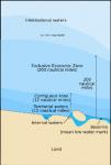
A baseline is the line from which the seaward limits of a state’s territorial sea and certain other maritime zones of jurisdiction are measured. Normally, a sea baseline follows the low-water line of a coastal state. When the coastline is deeply indented, has fringing islands or is highly unstable, straight baselines may be used.
 Eurasia Press & News
