Al Jazeera visualises Afghanistan – a mostly mountainous country of 38 million people – which has suffered decades of war.
Over the past few days, the Taliban has taken 26 of Afghanistan’s 34 provincial capitals.
The armed group now controls an estimated 65 percent of the country’s territory, as the US-led foreign forces are about to complete the pullout from the country after 20 years of war.
At least 244,000 people have been internally displaced since the beginning of May, when the Taliban group began multiple offensives against the Western-backed Afghan government.
Here are 10 maps to help you understand Afghanistan.
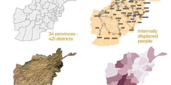
- 34 provinces – 421 districts
Afghanistan has a population of 38 million. About 4.5 million people (12 percent of the country) live in the capital Kabul, which is located in the east of the country. Other major provinces include Herat (1.9 million), Nangarhar (1.5 million), Balkh (1.3 million) and Kandahar (1.2 million).

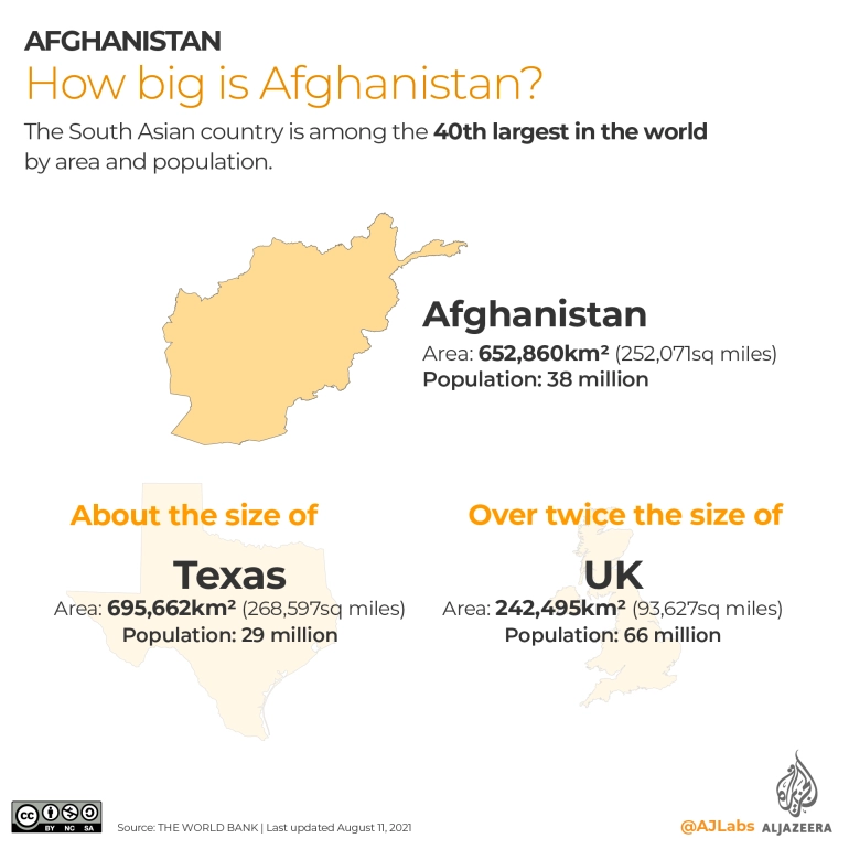
2. How big is Afghanistan?
The South Asian country is among the top 40 most populated countries in the world. At 652,860sq km (252,071sq miles), the country is roughly the size of the US state of Texas and more than twice the size of the UK.
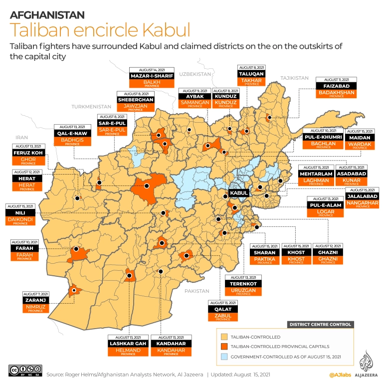
- Who controls what?
The Taliban has currently encircled Kabul and negotiating for a peaceful handover of the capital city.
The armed group has captured 26 provincial capitals in the past week, including the cities of Mazar-i-Sharif, Jalalabad, Khost, Sar-e-Pul, Sheberghan, Aybak, Kunduz, Taluqan, Pul-e-Khumri, Farah, Zaranj, Faizabad, Ghazni, Herat, Kandahar, Lashkar Gah, Feruz Koh, Qala-e Naw, Pul-e-Alam, Terenkot and Qalat.
The Taliban had already gained vast parts of rural Afghanistan since launching a series of offensives in May to coincide with the start of the final withdrawal of foreign forces.
At lightning speed, the armed group has progressed in various parts of the country, taking up important border posts and provincial capitals.
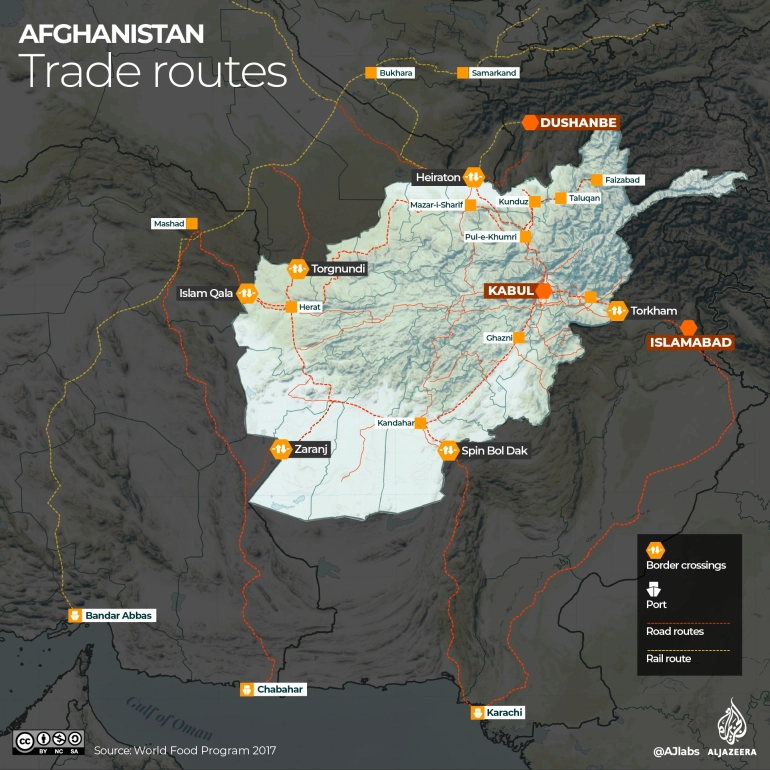
- Supply routes and border crossings
Landlocked Afghanistan relies on its neighbours for trade and supply routes.
Afghanistan has relied on Pakistan’s seaports for international trade and ground supply and logistics for NATO and US forces.
The two South Asian countries share a nearly 2,600km (1,615 miles) border and two operational border crossings. One of them, Spin Boldak, is under the Taliban control since late July.
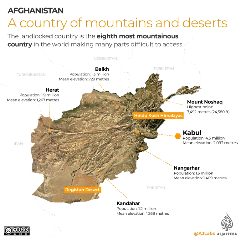
5. A country of mountains and deserts
It is the eighth most mountainous country in the world making many parts difficult to access. The country’s capital Kabul reaches a mean elevation of just more than 2km (6,562 feet) above sea level. The Hindu Kush Himalayas spans the northeast of the country while the southwest is mainly covered in desert.
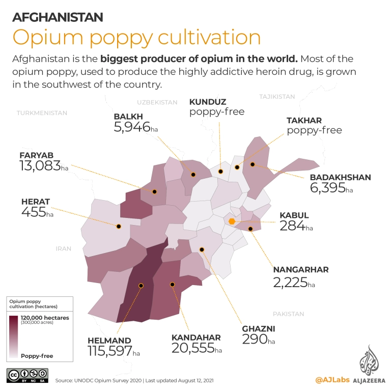
- Opium poppy cultivation
Afghanistan is the biggest producer of opium in the world. Most of the opium poppy, used to produce the highly addictive heroin drug, is grown in the southwest of the country.
According to the latest opium survey (pdf) conducted in 2020, 224,000 hectares (about 553,500 acres) of land was used to cultivate opium poppy across the country. More than half of all poppy cultivation – 115,597 hectare (285,650 acres) was cultivated in the southwestern province of Helmand alone.
According to UN estimates, about 6,300 tonnes of opium, with a value of $350m, was produced in 2020.
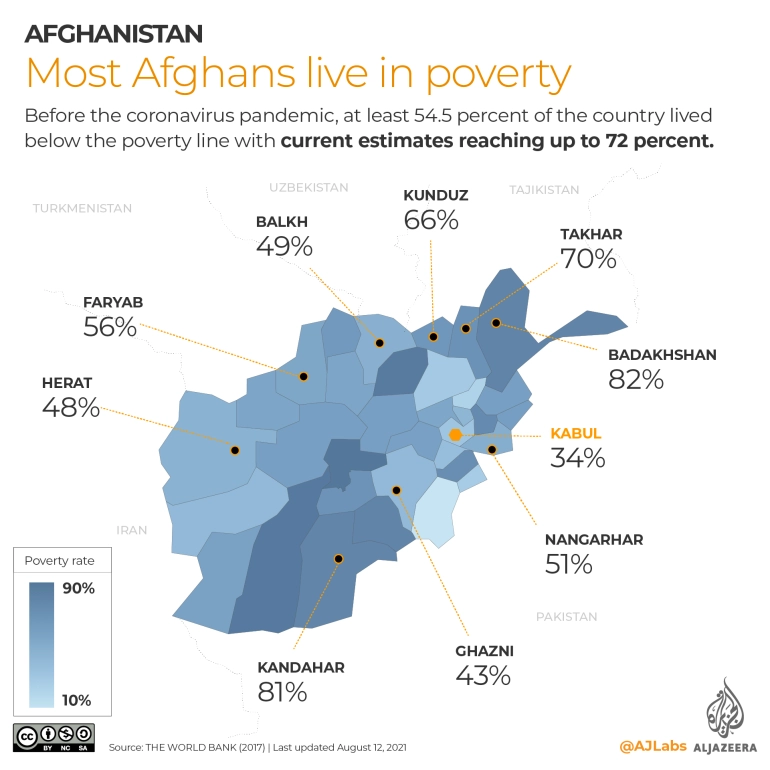
- Most Afghans live in poverty
Before the coronavirus pandemic, at least 54.5 percent of the country lived below the poverty line with current estimates reaching up to 72 percent.
- Very low literacy rates
Following decades of devastating wars, literacy rates in Afghanistan are among the lowest in the world at 43 percent. Just over half of all males above the age of 15 can read and write, while the ratio is much lower among females – less than one-third.

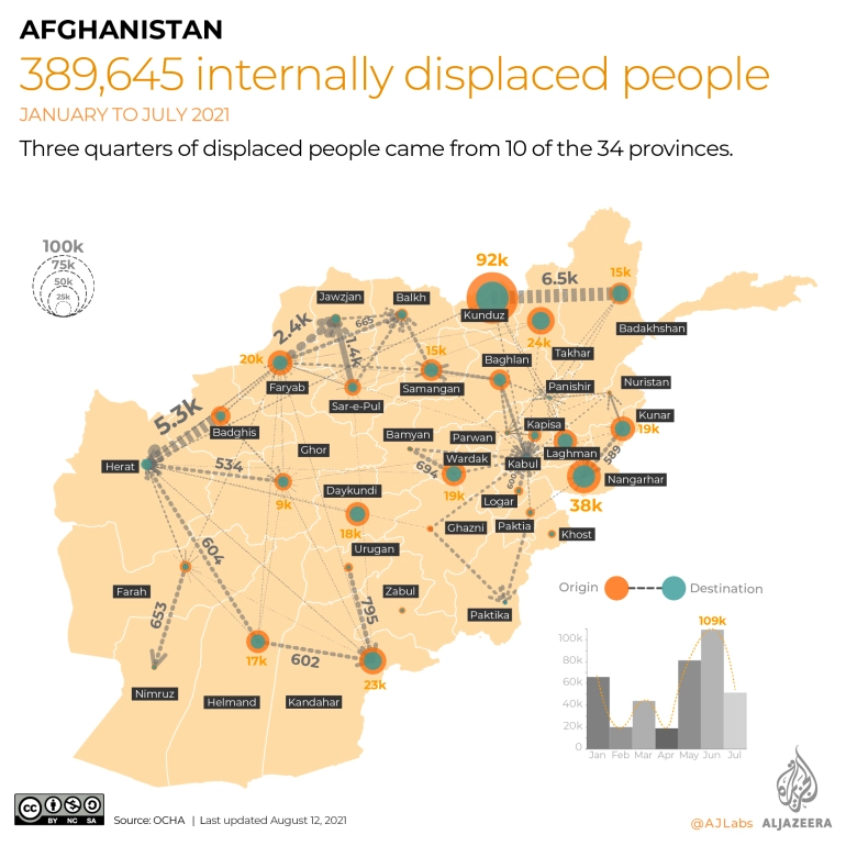
- Internally displaced people
According to the Office for the Coordination of Humanitarian Affairs (OCHA), at least 389,645 people, of which 59 percent are children, were displaced within Afghanistan from January 1 to July 24, 2021. In June alone, 109,000 people were internally displaced within the country.
Three quarters of the displaced people came from 10 of Afghanistan’s 34 provinces: Kunduz (92,000), Nangarhar (38,000), Takhar (25,000), Kandahar (24,000), Faryab: (20,000), Kunar: (19,500), Wardak: (19,000), Daykundi (18,300), Laghman (18,000), and Helmand (17,000).
The highest internal flows within the same province occurred in Kunduz (85,000), Nangarhar (38,000) and Takhar (25,000).
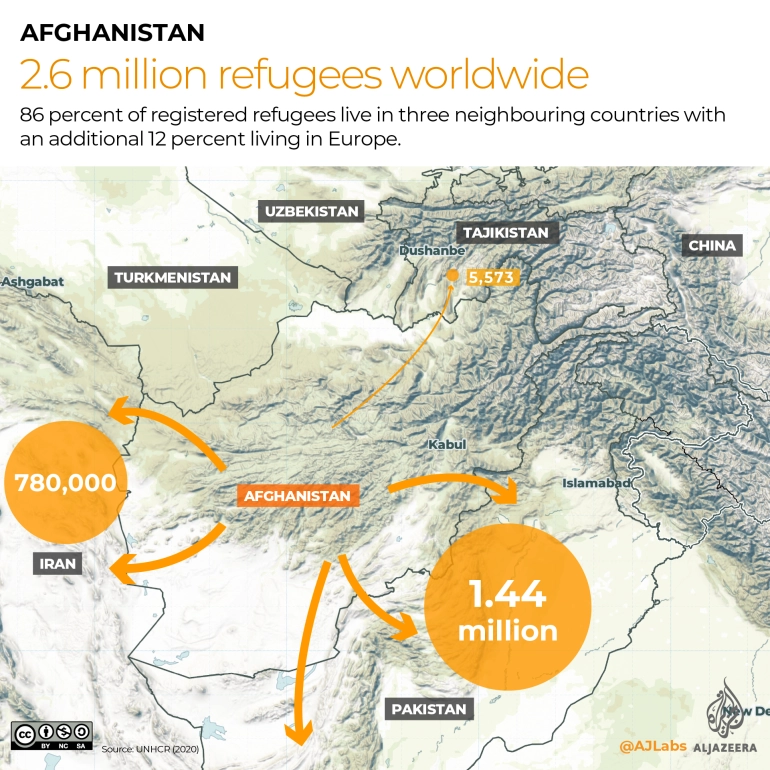
- Refugees in neighbouring countries
According to the latest report from UNHCR, the total number of Afghan refugees globally in 2020 reached 2.6 million.
Almost 86 percent of those registered refugees are in three of the neighbouring countries, with an additional 12 percent living in Europe.
In recent days, several European countries, including Germany, the Netherlands, France, Finland, Sweden and Norway, announced that they would temporarily halt any efforts to deport Afghan asylum seekers, a move that acknowledges the rapidly deteriorating security situation in the war-torn country.